Public domain
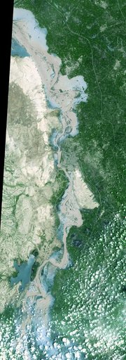
ASTER Maps Continued Pakistan Flooding
From the collection of NASA Image and Video Library. Free to download, adapt and use — no permission needed.
About this work
On Sept. 3, 2010, when NASA Terra spacecraft captured this image strip over the Indus River in Pakistan, severe flooding was still causing a major humanitarian crisis in Pakistan. The city of Hyderabad is near the middle of the image.
NASA Image and Video Library’s own descriptionCredit lineASTER Maps Continued Pakistan Flooding. NASA/JPL, 2010-09-07. Public domain. ID: PIA13369.
Similar works
 NASA Satellite Images Severe Flooding in Mozambique
 NASA Spacecraft Images Hudson River Flooding from Hurricane Irene
 Panguna Copper Deposit, Papua New Guinea
 Summer in the Arctic National Wildlife Refuge
 Earth Observations taken by Expedition 34 crewmember
 Earth Observations taken by Expedition 34 crewmember