Public domain
Using Gravity and Topography to Map Mars' Crustal Thickness
From the collection of NASA Image and Video Library. Free to download, adapt and use — no permission needed.
About this work
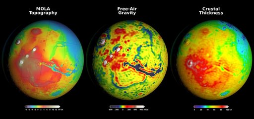
Newly detailed mapping of local variations in Mars' gravitational pull on orbiters (center), combined with topographical mapping of the planet's mountains and valleys (left) yields the best-yet mapping of Mars' crustal thickness (right). These three views of global mapping are centered at 90 degrees west longitude, showing portions of the planet that include tall volcanoes on the left and the deep Valles Marineris canyon system just right of center.
NASA Image and Video Library’s own descriptionCredit lineUsing Gravity and Topography to Map Mars' Crustal Thickness. NASA/JPL, 2016-03-21. Public domain. ID: PIA20277.