Public domain
Sentinel-6 Michael Freilich First Light Sea Level
From the collection of NASA Image and Video Library. Free to download, adapt and use — no permission needed.
About this work
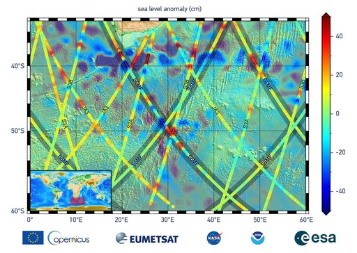
This graphic, released on Dec. 10, 2020, shows the first sea level measurements taken by Sentinel-6 Michael Freilich (S6MF), which launched Nov. 21, 2020. It focuses on the ocean off the southern tip of Africa, where red colors indicate higher sea level relative to blue areas, which are lower. Also included are sea surface height measurements from three other satellites for comparison: Jason-3 (JA3), Sentinel-3A (S3A), and Sentinel-3B (S3B).
NASA Image and Video Library’s own descriptionSubjects
Credit lineSentinel-6 Michael Freilich First Light Sea Level. NASA/JPL, 2020-12-10. Public domain. ID: PIA24135.