Public domain
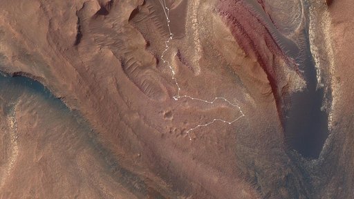
A Map of Curiosity's Difficult Climb
From the collection of NASA Image and Video Library. Free to download, adapt and use — no permission needed.
About this work
This map shows the route NASA's Curiosity Mars rover took from May into July 2023 to complete the most difficult climb of the mission. Starting in "Marker Band Valley" (the darker area at the top center), the route shows white dots for each stop the rover made. As it struggled to crest a 23-degree slope covered with slippery sand and wheel-size rocks, the rover experienced a number of faults that stopped it mid-drive.
NASA Image and Video Library’s own descriptionCredit lineA Map of Curiosity's Difficult Climb. NASA/JPL, 2023-08-03. Public domain. ID: PIA26017.