Public domain
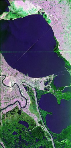
Space Radar Image of New Orleans, Louisiana
From the collection of NASA Image and Video Library. Free to download, adapt and use — no permission needed.
About this work
This image of the area surrounding the city of New Orleans, Louisiana in the southeastern United States demonstrates the ability of multi-frequency imaging radar to distinguish different types of land cover. The dark area in the center is Lake Pontchartrain. The thin line running across the lake is a causeway connecting New Orleans to the city of Mandeville. Lake Borgne is the dark area in the lower right of the image. The Mississippi River appears as a dark, wavy line in the lower left.
NASA Image and Video Library’s own descriptionSubjects
Credit lineSpace Radar Image of New Orleans, Louisiana. NASA/JPL, 1998-04-14. Public domain. ID: PIA01300.